

 Maps - Flat Earth Map - Gleason's New Standard Map Of The World - Large 24" x 36" 1892 Poster Includes FREE eBooks and Flat Earth Bumper Sticker
 Maps - National Geographic World Wall Map - Executive - Laminated (46 x 30.5 in) (National Geographic Reference Map)

Phoenix, Arizona Wall Map, Large - 22.75" x 21.5" Laminated
 Maps - Phoenix, Arizona Wall Map, Large - 22.75" x 21.5" Laminated
 Maps - National Geographic: United States Classic Enlarged Wall Map - Laminated (69.25 x 48 inches) (National Geographic Reference Map)
 Maps - United States Map with State Flags Poster - Laminated 14x19.5 in. - Educational Poster, USA Map for Kids, Elementary Classroom Decorations, and Teacher Supplies
 Maps - Antique Style USA Map - Wall Chart Map of The United States of America - Made in The USA - Updated (LAMINATED, 18" x 29")
 Maps - Riley Creative Solutions Middle East CIA Map | Iraq Iran Israel Political 2003 Wall Art Poster (2 Sizes) (11"x13")
 Maps - National Geographic World, Pacific Centered Wall Map - Classic - Laminated (46 x 30.5 in) (National Geographic Reference Map)

Marauder's Map Hogwarts Wizarding World Harry Potter Warner Bros LIMITED **NEW**
Maps - Marauder's Map Hogwarts Wizarding World Harry Potter Warner Bros LIMITED **NEW**
 Maps - JARLINK Scratch Off USA Map Poster, 12x17 inches United States Map with Unique Accessories Set, Personalized Travel Poster, Gift for Travelers


 Maps - Black Cork Globe with Push Pins - 6” Globe with Map of the World and Rotating Stand for Children or Adults, 100 Metallic and 100 Colored Push Pins - World Map for Home, Office, Classroom, Travel, Kids
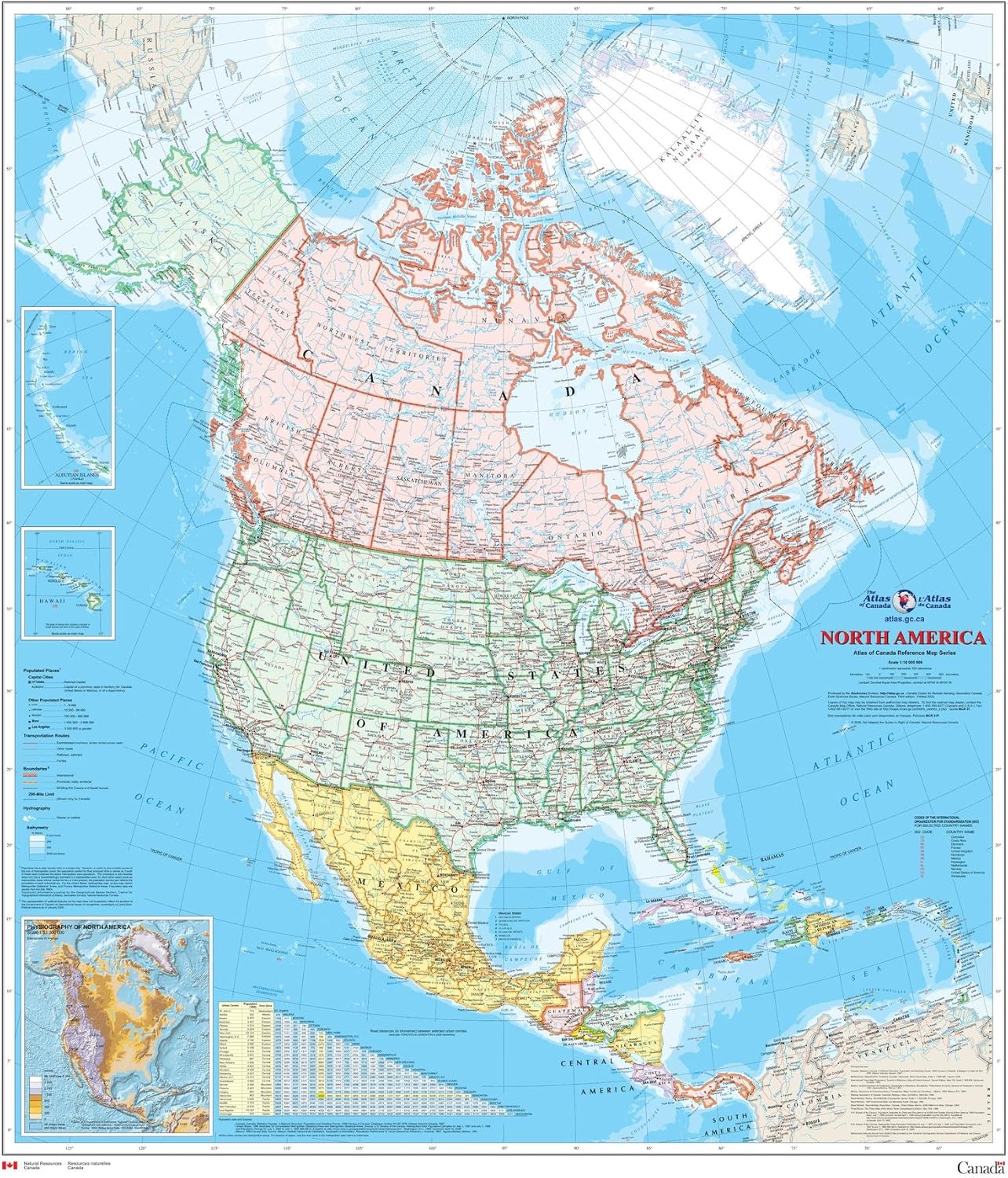
North America Wall Map - Atlas of Canada - 34" x 39" Laminated
Maps - North America Wall Map - Atlas of Canada - 34" x 39" Laminated
![Maps - National Parks Scratch Off Map of United States Poster [ALL 63 Parks] INCLUDES Wildlife, US Travel Map Print, USA Gift for Travelers Road Trip Adventure Journal, Fits 16”x20” frame by Bright Standards](https://images-na.ssl-images-amazon.com/images/I/81R8JH850ML._AC_SL1500_.jpg) Maps - National Parks Scratch Off Map of United States Poster [ALL 63 Parks] INCLUDES Wildlife, US Travel Map Print, USA Gift for Travelers Road Trip Adventure Journal, Fits 16”x20” frame by Bright Standards
Maps - National Parks Scratch Off Map of United States Poster [ALL 63 Parks] INCLUDES Wildlife, US Travel Map Print, USA Gift for Travelers Road Trip Adventure Journal, Fits 16”x20” frame by Bright Standards

 Maps - Large Blank United States Outline Map Poster, Laminated, 36” x 24” | Great Blank Wall Map for Classroom or Home Study | Free Dry Erase Marker Included | Includes Detailed Laminated Answer Sheet
 Maps - Antique Style Laminated World Map - 18" x 29" - Wall Chart Map of the World - Made in the USA - Updated (LAMINATED, 18" x 29")
 Maps - National Geographic World Wall Map - Classic - Laminated (43.5 x 30.5 in) (National Geographic Reference Map)

 Maps - National Geographic United States Wall Map - Classic (43.5 x 30.5 in) (National Geographic Reference Map)
 Maps - Mr. Pen- United States Map for Kids, 14.5”x 24.6”, Us Map for Kids Learning, Map of Usa, Wall Maps, Usa Map Poster, Map of the United States, Kids Map United States, Maps for Kids of The United States
 Maps - USA Photo Map - Travel Map Sticker Collage - 24 x 36” - Made in USA (Dark Blue, Pine Wood Frame Hanger)

24x36 World Classic Elite Wall Map Mural Poster Laminated
Maps - 24x36 World Classic Elite Wall Map Mural Poster Laminated

Maps International Giant World Map - Classic Large World Map Poster - Laminated - 46 (h) x 77.5 (w)
Maps - Maps International Giant World Map - Classic Large World Map Poster - Laminated - 46 (h) x 77.5 (w)

The Great Awakening Map poster canvas print 16x24inch Unframed
Maps - The Great Awakening Map poster canvas print 16x24inch Unframed
![Maps - Palace Learning 2 Pack - Blank USA Map Outline Poster + Simplified USA Map for Kids [Blank] (LAMINATED, 18](https://images-na.ssl-images-amazon.com/images/I/81duZ2aiFzS._AC_SL1500_.jpg) Maps - Palace Learning 2 Pack - Blank USA Map Outline Poster + Simplified USA Map for Kids [Blank] (LAMINATED, 18" x 29")
Maps - Palace Learning 2 Pack - Blank USA Map Outline Poster + Simplified USA Map for Kids [Blank] (LAMINATED, 18" x 29")
 Maps - Israel with West Bank and Gaza Strip disputed territories - Detailed Political Wall Map Poster Large Print Rolled 24W"x38"H - paper


Discover More Best Sellers in Maps
Shop Maps
Metamorphosis: Franz Kafka (Little Clothbound Classics)
Maps - Metamorphosis: Franz Kafka (Little Clothbound Classics)


 Maps - ZOCO – United States Map with Capitals Poster – Laminated 17x22 – Educational USA Wall Chart for Kids – North America Geography, Social Studies Classroom Decor
 Maps - Scratch off Map United States of America Travel Poster 17 x 24 Wall Art Decor Photos of National Parks and other Iconic locations Includes State Flags Scratch Pen Guitar Pick and Gift Tube
 Maps - Epic Adventure Maps The United States Push Pin Map 24" x 17" - Unframed Travel Map to Mark Your Travels Around The USA - Multicolored Pushpins Included

Pictorial Poster Map of Italy - 23.4 x 16.5 inches - Paper Laminated
Maps - Pictorial Poster Map of Italy - 23.4 x 16.5 inches - Paper Laminated
 Maps - USA Push Pin Map 24" x 17" - USA Poster to Mark Your Adventures Around The USA - Travel Camping Gift - Camper Decor (Framed Beige)

Pilot FRIXION POINT KNOCK Biz Marble Pink LFPK-3SS4-MAP
Maps - Pilot FRIXION POINT KNOCK Biz Marble Pink LFPK-3SS4-MAP

33"x24" Poster Verwaltungskarte Bundeslander Deutschland, Districts of Germany Map【Coated Paper】
Maps - 33"x24" Poster Verwaltungskarte Bundeslander Deutschland, Districts of Germany Map【Coated Paper】
