
Features
Top quality National Geographic Map
30x43 Poster Size
Durable 3mil Lamination
Also available Wood Framed from Swiftmaps
Description
Book Synopsis: Expertly researched and designed, National Geographic's World Wall Map is the authoritative map of the world by which other reference maps are measured.
Product Features:
- Colorful Decorator style map with vibrant color palette that fills each country for easy identification
- Background shows mountain ranges and valleys in subtle shaded relief with mountain ranges labeled
- Major water bodies including rivers, lakes, glaciers, oceans, seas, gulfs, bays, straits, and bathymetry
- Clearly defined international boundaries, cities, islands, airports, and physical features
- Thousands of place names carefully and artfully placed to maintain legibility in heavily populated areas
- Up-to-date international boundaries and territorial control reflect de facto status on the ground
- Meticulously researched using multiple authoritative sources including the U.N., U.S. Board on Geographic Names, and policies of individual governments.
- Accurate place names use a combination of conventional English names, official national names, and standard transliterations for non-Latin alphabets.
- Drawn in Winkel Tripel projection with distortions minimized unlike other World maps (e.g. Greenland is shown the same size as Argentina, not South America)
- Corner inset maps feature vegetation, land use, population density, and north and south polar regions
- The map is encapsulated in heavy-duty 1.6 mil laminate which makes the paper much more durable and resistant to the swelling and shrinking caused by changes in humidity.
- Laminated maps can be framed without the need for glass, so the frames can be much lighter and less expensive.
- Map Scale = 1:29,802,000
- Sheet Size = 46" x 30.5"
Read more
Details
Looking for the perfect wall decor that is both beautiful and educational? Look no further than the National Geographic World Wall Map - Decorator - Laminated. This map is not just your regular reference map; it is the authoritative map of the world that sets the standard for all other maps. With its vibrant colors and detailed features, this map will add life to any room.
The colorful decorator style and vibrant color palette of this map make it easy to identify and differentiate between countries. The background highlights mountain ranges and valleys with subtle shaded relief, giving the map a three-dimensional feel. Major water bodies are clearly labeled, allowing you to explore the world's oceans, seas, rivers, lakes, and more.
What sets this map apart is its meticulous research and up-to-date information. The international boundaries, cities, islands, and physical features are accurately defined, reflecting the current status on the ground. Thousands of place names are carefully placed to ensure legibility, especially in heavily populated areas. You can trust that this map is reliable and accurate, as it is based on multiple authoritative sources such as the U.N. and U.S. Board on Geographic Names.
The World Wall Map is not just informative but also visually appealing. Drawn in the Winkel Tripel projection, distortion is minimized to provide a more realistic representation of the world. This means that Greenland is shown accurately, not exaggerated in size like on other maps. Inset maps offer additional information on vegetation, land use, population density, and the north and south polar regions.
With its heavy-duty laminate coating, this map is built to last. The laminate makes the paper durable and resistant to the changes in humidity, preventing it from swelling or shrinking. You can even frame the map without glass, making the framing process lighter and less expensive. The map scale of 1:29,802,000 and a sheet size of 46" x 30.5" ensure that you can explore the world in detail.
Don't miss out on owning the ultimate world map - the National Geographic World Wall Map. It is both a stunning piece of art and a valuable educational resource. Enhance your space and broaden your knowledge of the world. Visit our website to get your very own National Geographic World Wall Map today! Get it here
Discover More Best Sellers in Maps
Shop Maps
Rand McNally Easy to Read: Connecticut, Rhode Island State Map
 Maps - Rand McNally Easy to Read: Connecticut, Rhode Island State Map

 Maps - UK Map - Classic Wall Map Of The United Kingdom Poster - Front Lamination, UK Map - Classic Wall Map Of The United Kingdom Poster - Front Lamination - 33 x 23in

The Constellations Glow-in-The-Dark Star Map (Northern Hemisphere)
 Maps - The Constellations Glow-in-The-Dark Star Map (Northern Hemisphere)
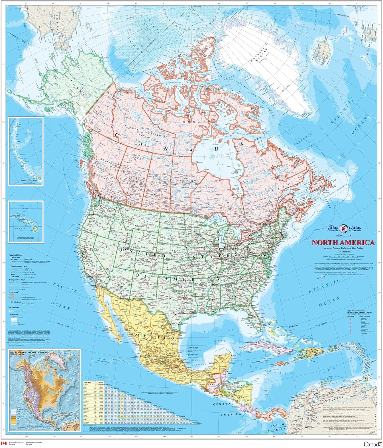
North America Wall Map - Atlas of Canada - 34" x 39" Laminated
Maps - North America Wall Map - Atlas of Canada - 34" x 39" Laminated
 Maps - Waypoint Geographic Contemporary Series USA Wall Map, Laminated World Map Poster, Educational Wall Art For Home, Classroom, or Office, Unique Gifts, 48” x 38”

Cool Owl Maps United Kingdom & Ireland Wall Map Poster - Rolled 24"x27" (Laminated)
Maps - Cool Owl Maps United Kingdom & Ireland Wall Map Poster - Rolled 24"x27" (Laminated)
 Maps - Educational Blank Outline Maps, 2-Sided World & US, 17” x 11”, 50-Pack | Great Blank Map Worksheets for Classroom or Home Study | Laminated Answer Sheet Included | Map Packs are Perfect Desk Size
 Maps - HISTORIX Vintage 1896 Map of Louisiana - 18x24 Inch Vintage Map of Louisiana Wall Art - Old Louisiana Wall Map Indexed Showing Cities Towns and Railroads - Louisiana Wall Decor
 Maps - Dekali Designs Kids World Map Coloring Poster - 35 x 52 Inches Jumbo Coloring Poster With World Flags for Classroom, Home, Birthday Parties or Other Events

