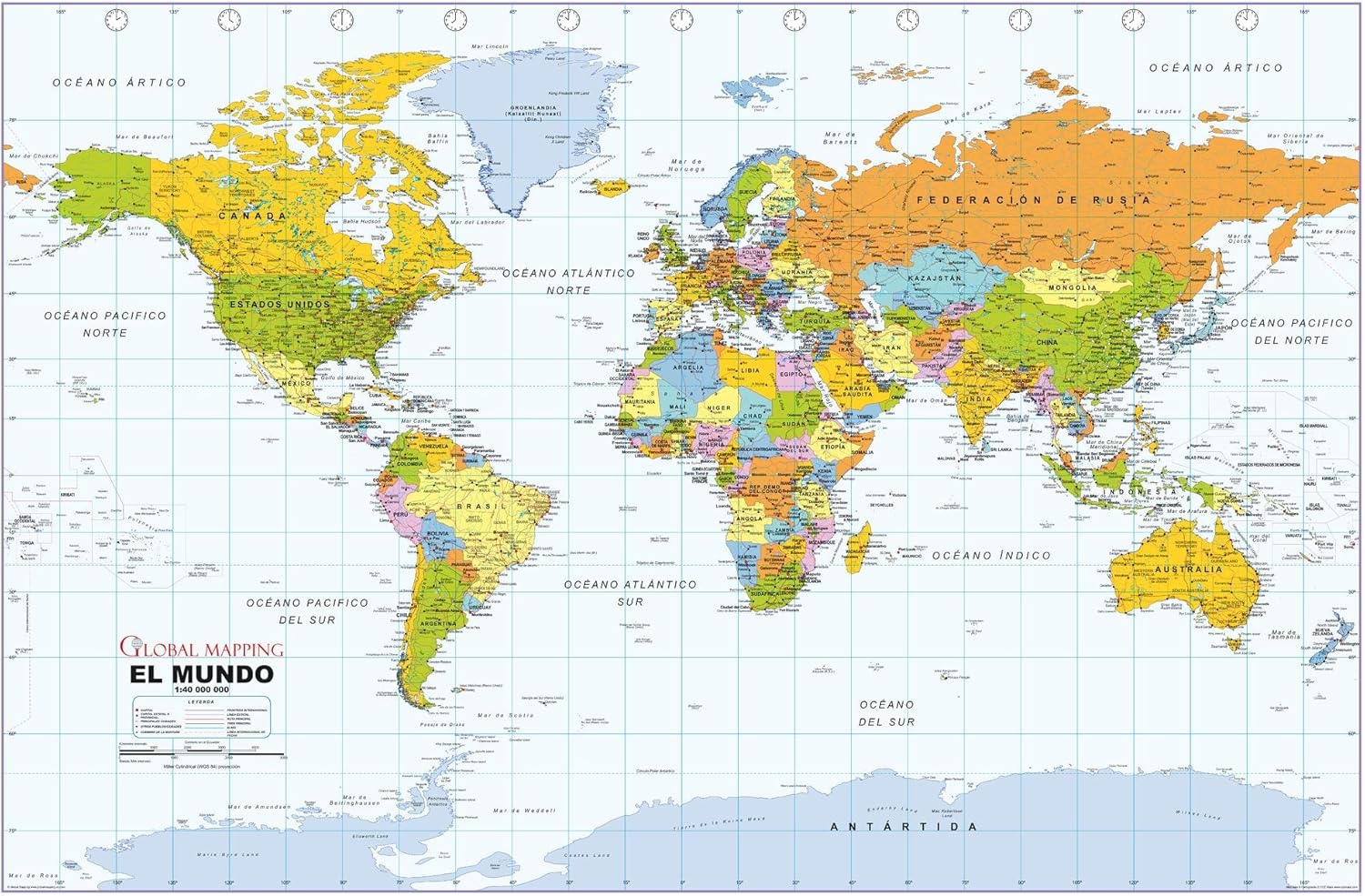
Political World Wall Map, Spanish Language, Mapa político del mundo, idioma español - 40.75 x 27 inches - Paper - Flat Tubed

$31.99
Features
- Dimensions: 40.75 x 27 inches.
- Printed on paper.
- Flat map, tubed for shipping.
- Political World Wall Map in Spanish.
- Mapa político del mundo en español.
- Created by England's wall map cartographic specialists Global Mapping.
- Scale 1:40,000,000.
Details
Looking for a captivating and educational addition to your home or office? Look no further than our Political World Wall Map in Spanish! This large map, measuring an impressive 40.75 x 27 inches, is the perfect way to explore and appreciate the political landscape of the world in the comfort of your own space.
Printed on high-quality paper, this map features vibrant and accurate colors that will bring your walls to life. Whether you're a language enthusiast or simply want to brush up on your Spanish, the Spanish language labeling on this map will make your learning experience even more enjoyable.
Created by England's acclaimed wall map cartographic specialists, Global Mapping, this map benefits from their vast expertise and attention to detail. With a scale of 1:40,000,000, you can trust that this map provides accurate representations of countries, continents, and oceans, making it a valuable tool for both educational and reference purposes.
For your convenience, this map comes flat and tubed for shipping, ensuring that it arrives in pristine condition. Hang it as is or frame it to add a touch of sophistication to your space. Enhance your knowledge of the world and impress your guests with our Political World Wall Map in Spanish.
Ready to take your geography knowledge to the next level? Get your own Political World Wall Map in Spanish today by clicking here. Start exploring the world in a whole new way!
Discover More Best Sellers in Maps
Shop Maps

24x36 United States, USA US Executive Wall Map Poster Mural (24x36 Paper)
 Maps - 24x36 United States, USA US Executive Wall Map Poster Mural (24x36 Paper)

Marauder's Map Hogwarts Wizarding World Harry Potter Warner Bros LIMITED **NEW**
 Maps - Marauder's Map Hogwarts Wizarding World Harry Potter Warner Bros LIMITED **NEW**

Maps International - Scratch Off USA Map Golf Print - Gifts for Golfers - 17 x 22 inches
Maps - Maps International - Scratch Off USA Map Golf Print - Gifts for Golfers - 17 x 22 inches
 Maps - Gifts Delight Laminated 24x28 Poster: Large Scale Detailed Political map of The Middle East with Relief, Major Cities and Capitals


Cool Owl Maps Florida State Wall Map Poster Rolled (Laminated 24"Wx25"H)
Maps - Cool Owl Maps Florida State Wall Map Poster Rolled (Laminated 24"Wx25"H)

Cool Owl Maps Georgia State Wall Map Poster Rolled 24"Wx30"H (Laminated)
Maps - Cool Owl Maps Georgia State Wall Map Poster Rolled 24"Wx30"H (Laminated)

NewSpaceView Natural Learning 2-Sided Placemat (5 Children’s Desk Maps: USA/USA Centered World Map)
Maps - NewSpaceView Natural Learning 2-Sided Placemat (5 Children’s Desk Maps: USA/USA Centered World Map)
